By Inc42 Media
The increasing deployment of satellite constellations is transforming industries like defence, agriculture, telecommunications and functions related to smart city planning, maritime activities, environmental studies, and disaster management.
However, extracting insights from raw satellite data involves sending the data to ground stations for processing, which is both time-consuming and expensive.
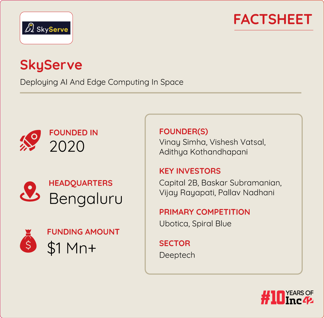
SkyServe, founded in 2020 by Vinay Simha, Vishesh Vatsal, and Adithya Kothandhapani, aims to change this decades-old practice. Based in Bengaluru, SkyServe has developed STORM, an AI-enabled edge computing platform that processes data directly on satellites in space and delivers real-time analytics to users on Earth.
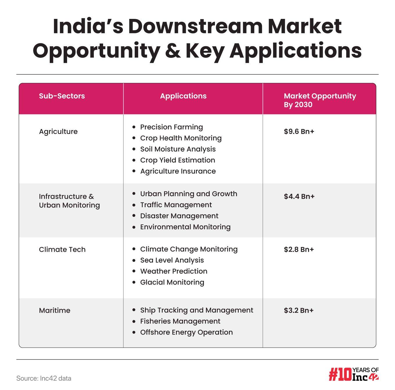
Notably, India, supported by collaborations between private and public entities and various policy incentives, now hosts over 150 spacetech startups. According to Inc42, India’s spacetech market, projected to grow at a 26% CAGR from 2023 to 2030, could exceed $77 Bn, and the downstream market accounts for two-thirds of this potential.

Operating in this high-octane downstream market, SkyServe, with its innovative tech stack, is on a mission to make waves in the way data is utilised across industries.
So far, the startup has raised more than $1 Mn in a Seed funding round. Its investors include Baskar Subramanian, cofounder and CEO of Amagi Media Labs, Vijay Rayapati, CEO and cofounder of AtomicWorks, among a few other angels and institutional investors.
SkyServe is also looking to raise a Series A funding round to the tune of $8 Mn-$10 Mn this year.
The Genesis Of SkyServe
Speaking with Inc42, cofounder and CEO Vinay Simha said that SkyServe today exists to solve a major challenge ailing the space industry, which is that traditional satellites do not have enough computational power to process captured data or images, mainly due to high launch costs and the complexities of adding new components.
Other challenges include risks of failure, power dependencies, standard connectivity issues, and the harsh space environment, which makes ground-based data processing the preferred method.
“Now, with the cost of the launch being cheaper and the miniaturisation of electronics, multiple new players are coming up with smart satellites. That’s when we thought to look differently at the way Earth data is being captured, assimilated, and processed, leading to the foundation of SkyServe,” Simha said.
The cofounder began developing an edge computation platform, STORM, in 2022 to leverage AI and edge computing to address these bottlenecks. STORM processes data from various sensors, such as synthetic aperture radar (SAR) and hyperspectral, for multiple applications across industries.
SkyServe has also partnered with satellite operators and OEMs to deploy AI in space, which can enable downstream customers such as geospatial analytics companies and solutions providers with space insights.
Its use cases include wildfire detection, ship detection, port monitoring, mine monitoring, and national border surveillance, among others.
The first deployment of STORM took place in 2023 for flight testing and qualification. The newest version of STORM was deployed earlier this year in two of startup’s missions – Denali and Matterhorn.
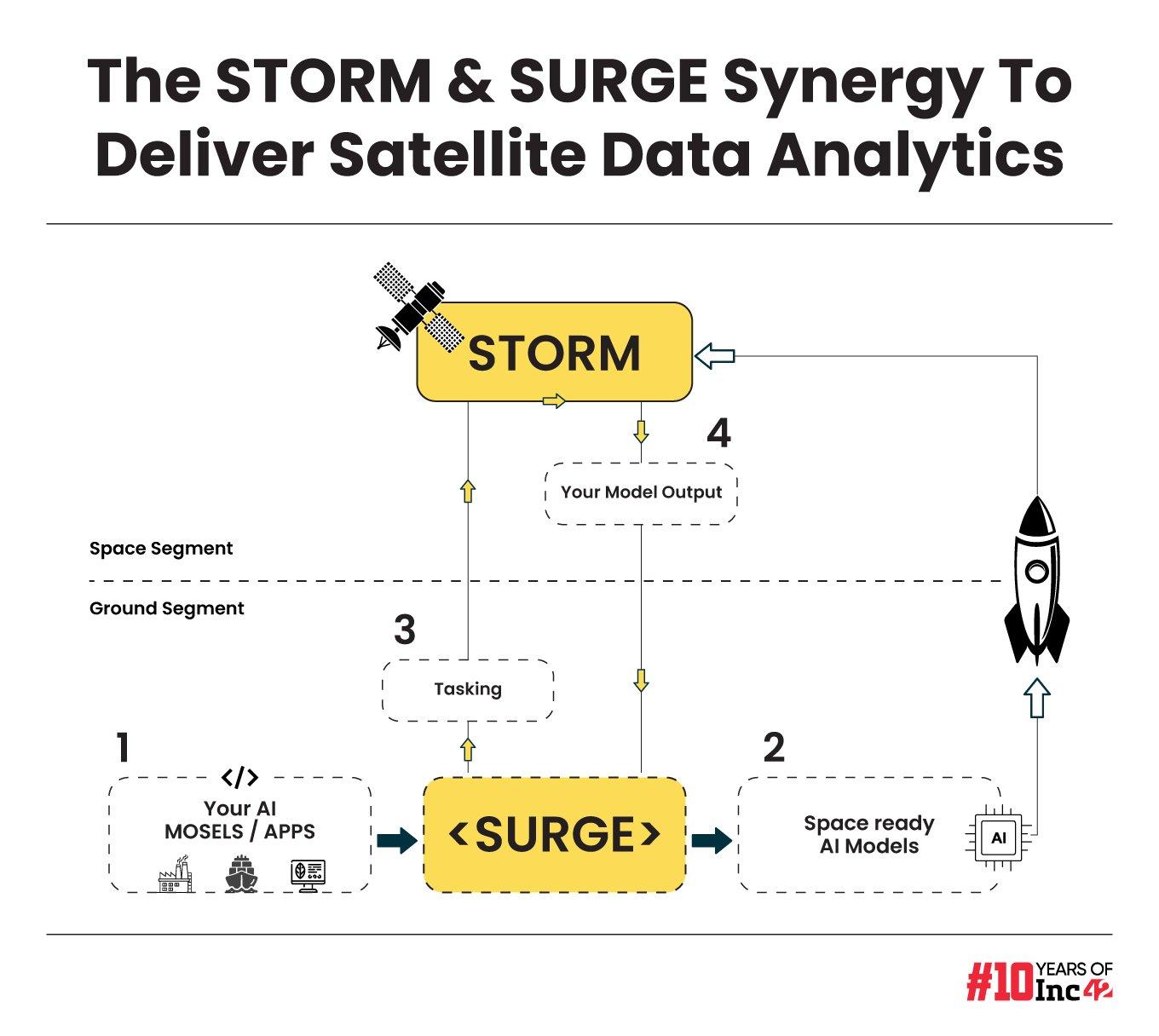
Besides, SkyServe has another platform SURGE, which is an on-ground infrastructure to develop, deploy, and manage edge-ready models on satellites.


As shown in the diagram above, before the launch of AI models with STORM, SURGE enables optimising models for edge deployment, ensuring compatibility and readiness for functioning on satellite payload software and hardware. Post the launch, it allows users to interact with their models and manage them according to their business needs.
The SkyServe Missions
So far, the spacetech startup claims to have undertaken over 16 missions but it has publicly announced only three – K2, Denali, and Matterhorn.
As part of its first mission, Mission Matterhorn, SkyServe partnered with a European space logistics infrastructure provider, D-Orbit, earlier this year to deploy STORM on a satellite launched by SpaceX.
Last month, the satellite, which is now equipped with STORM, demonstrated its capabilities by performing intelligent tasks such as error correction in imagery, cloud and water cover removal, and vegetation identification within seconds of capturing data over the Egypt-Sinai Peninsula.


Next, as part of Mission Denali, SkyServe partnered with Loft Orbital to deploy STORM. Fed with its customers’ AI models, STORM is leveraging Loft’s satellites to deliver on-demand predictions for wildfire tracking, irrigation, mining logistics, maritime surveillance, energy, utilities, and carbon monitoring.
Currently, SkyServe is gearing up for Mission K2, which is scheduled for a launch aboard ISRO’s PSLV C59 in September this year.
How Does SkyServe Make Money?
The startup largely earns its revenue by providing AI-as-a-Service where it charges its customers based on the area for which it provides data and the number of times it requires to visit the area to provide the insights.
Simha said that typically, ordering a satellite image can cost around INR 21,000 ($250) for an area of 10 sq km, and extract analytics from it costs an additional INR 6,000 ($70).
“With SkyServe STORM – ‘insights as a service’, we give at least 3X cost reduction, real-time inferencing and seamless services to our client across different satellite sensors including multispectral and hyperspectral, to deliver the end-use value for geospatial companies and analytics teams in the government and enterprises,” said Simha.
Besides, it also builds entire solutions in collaboration with its partner satellite companies as per customer’s requirements.
The startup is currently in the early stage of revenue generation. With the ongoing missions and those in the pipeline, SkyServe claims to be already on a path to keep generating “decent” revenue over the next two years.
What’s Next For SkyServe?
Currently, a majority of SkyServe’s traction comes from the US, followed by Europe, given the maturity of these markets in terms of geospatial image usage.
However, the company expects the APAC region, including India, to also gradually mature, and the demand for edge-based affordable geospatial data to increase in the coming years. The startup is planning for about 18-20 missions over the next two years.
In an attempt to create widespread awareness about the power of geospatial images and help clients understand its offerings, SkyServe has built a web-based dashboard, earthsights. The free-to-use tool allows any user to study various aspects, including vegetation index, water index, soil temperature and moisture, surface pressure, and specific humidity of cities across the world.
With a current client base of six to seven entities in the areas of urban water body detection and monitoring of wildfire, SkyServe aims to increase the number of clients to 20+ in the next 18 months.
Meanwhile, SkyServe directly competes with only a handful of global entities such as Ireland-based Ubotica, Australia-based Spiral Blue, and US-based Descartes Labs, among others. In India, too, there are multiple edge computing companies which are working with AI, catering to other fields of study.
With the spacetech ecosystem leapfrogging in the country, tracking the growth of SkyServe as an early mover will be compelling to watch in the coming years.

